From Whence the Prairie
The story of the Red River Valley begins
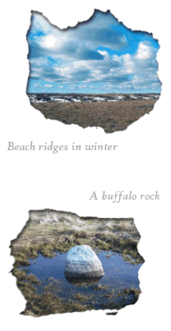
with geology, and the most recent chapters go like this: In the last ice age, the Wisconsinan ice sheet descended from the north like an infinitesimally slow storm, scouring much of the northern tier of North America including the Northern Plains with giant lobes of glacial ice often measuring a half-mile thick. The vast glacial Lake Agassiz formed as this ice began to recede about 12,000 years ago. It filled a basin that reached from the Red River Valley to the edge of Hudson Bay. Even today, thousands of years later, traces of this lake remain. As the water receded, it left behind a series of sandy beaches that today appear as subtle ridges on the prairie.
In the fur trade era of the 1800s, these beach ridges were a vital link in an early transportation network. The ox carts of the Metis fur-traders are legendary - it is said you could hear the ear-piercing squeak of their wooden axles for miles. These carts were the box cars of their era, carrying hundreds of pounds of furs destined for the trading post in St. Paul. They traversed the often wet, boggy tallgrass prairie by traveling along the subtle ridges. You might think of the glacial beach ridges as precursors to the modern highway. At Oakville Prairie, you can walk along a pair of ridges - the Ojata beach ridges - that rise above the prairie.
In North Dakota, these ridges stretch across the prairie in a line that generally runs from the north-northwest to south-southeast, and you can see them as you travel across the Red River Valley. The notorious salinity of Grand Forks County grasslands comes from the saltwater escaping from aquifers deep underground. It profoundly shapes the face of the landscape. The rocks and boulders scattered across the prairie have a story, too. Carried by the glaciers of the last ice age, and
then left behind as the earth's climate warmed, today these rocks dot the
landscape. Geologists call them "glacial erratics," so-named for the random pattern in which they appear on the landscape. Buffalo sometimes gathered and literally "scratched their backs" on these giant boulders on the open prairie. In the process, buffalo carved out giant wallows that, in especially wet climatic cycles, become wetlands brimming with life. These boulders are called "buffalo rocks". They are still found on the native prairie of Grand Forks County, where the geologic story is written in clear, bold strokes.
Home | Partners | Field Guide | Heroes | Gallery | Links | Contact Us
Grand Forks County Prairie Partners - 2011 - All Rights Reserved
